Pages

Showing posts with label Google Earth. Show all posts

Friday, March 26, 2010

Growing Up

I was inspired by Dean Shareski's blog post (see post for his inspirations) to use Google's Street View to give a short overview of where I grew up (none of my family still lives in the houses I showed). I think this could be a great way for students to tell their story, or narrate a fictional one with a setting of their choosing. If students didn't want to hear themselves speak, or you didn't want to mess with screen recording, a text version of this could be done using kmz files in Google Earth to tour the world.
Shareski used Jing and pieced together less than 5 minute clips to make his video (free Jing maxes at 5 minutes). I used iShowU HD because I already had it on my computer. I did have to do some editing in iMovie to get it under 10 minutes (max allowed by YouTube). I'm not a huge fan of iShowU (see: audio quirk towards the beginning...happens more often than I like to admit), but it gets the job done.
Enjoy!

Monday, December 31, 2007

Google Earth 2007

We here at the Tech Fridge are getting ready for one last 2007 party, but thought it would be best to get all of our loyal consumers something to read for the new year. With so many "year in review" items coming out, why not just steal from someone else?
The Google Earth Blog put out a list of the Top 10 New Google Earth Features (they also have a link for the new updates of 2006 and the Top 25 stories of Google Earth in 2007). Of the 10 features they listed, I think there are three that are most beneficial for education:
1. Google Sky Mode: I am far from an astronomer, but when sky mode came out in August, I had the opportunity to ask some astronomers about the accuracy of sky mode. They said that while it is accurate, it is far from complete. They did acknowledge that it would extremely difficult for a free program to offer a complete listing of the universe. Understandable. What a great way to enhance what you are already doing in your astronomy unit?
2. YouTube layer: Google introduced many layers this year that include the ability to see pictures, learn more about the history of areas, etc. But by far my favorite has been the YouTube layer. We've used it to make documentaries about some of our schools. So when prospective parents are moving to the district, they could use Google Earth to learn more about our schools. While I worry about random people putting random videos on our buildings (Ever looked at the South Pole? Try it and you'll see what I mean.) and if there will ever be a cleaning of this layer (go look at the White House), I think this layer is great.
3. Weather layer: In November the real time weather layer was introduced. In education, Google Earth can be used very easily in social studies and to get a fairly accurate visual of a non-fiction setting for books (among many other things, of course). Last year we did a video chat with a school in California, and they always thought it was funny that it was 10 degrees with three inches of snow on the ground. But they always had to ask us what the weather was like. We used Google Earth to see what their school looked like, and how cool would it have been to look at the building and the weather at the same time. The weather layer gives you more information about the places you are interested in around the world. Studying the Iraq war? You could use the weather layer to compare and contrast weather conditions from where you are to what it's like on that side of the world. 
With all of the updates to Google Earth just this past year, it will be very interesting to see where they take this outstanding application.
From all of us here at the Tech Fridge, we wish you the happiest of holidays and hope that you have a wonderful New Year's Eve. See you next year!

Monday, November 12, 2007

Putting your video on Google Earth

Here at the Tech Fridge, we feel there is really no way to be too cool. So we are going to add some videos to Google Earth next week. During our HAL seminar, students are going to take pictures of their school building and do some voice over narrating and create a timeline of their building's history. Then we will upload that video to You Tube and on to Google Earth. That way, if parents or students use Google Earth to see what life will be like in their new school, they will get to see and hear about it.
How do you get from You Tube to Google Earth, you ask? Welcome to today's post!

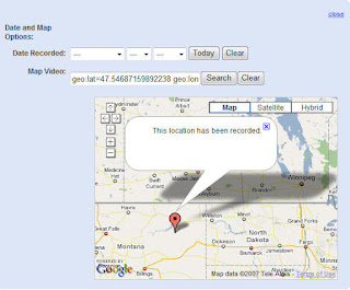
Once you have uploaded your video to You Tube, click on the button to edit your video. The second to last edit option is 'Date and Map Options.'
You can drag the red marker to where you want the video to be found in Google Earth. Get a closer view by either using the plus button in the top left corner or by double clicking to zoom in. You should see your Map Video update each time you move the marker and the "This location has been recorded." bubble appears. You do not have to add in a date recorded if you don't want to. It does not matter for Google Earth.
Once you have finished, there is an 'Update Video Info' button at the bottom of the page. I've had some issues with Internal Server Errors this weekend, but it did post my video and added it to Google Earth. My only reservation is putting student pictures, names, etc. on Google Earth. Our pictures will not include any close up student pics and will definitely not include any names. As we discussed around the Fridge the other day, newspapers do it all the time, putting names of students with names of schools, and parents and grandparents think its cute. My personal policy is to leave it off if at all possible.
Try this with your students and you'll be cool as a cucumber! Visit again to let us know how it goes!

Monday, September 10, 2007

Using Google Earth in the Classroom


Oops, wrong button. Sorry for those you using Google Reader. I didn't mean to post this twice today. I thought my cursor was there, but it was there...you know how it goes. Its still pre-lunch on a rainy Monday. What do you expect?

Google Earth is technically nuts. I have never seen a project that I use a lot that I know so little about. Please, if you are an advanced Google Earth user, just move on to one of the other posts. I, unfortunately, can't give you anything on the advanced features. For those of us novice users or experimenters, you will find something that you should be able to sink your teeth into.
Google Earth is a free, downloadable application that is similar to Google Maps, but 500 times cooler. Many people around the world have added their own little bits of information to it through Google's online community. One of the biggest informants for me is Sightseer, Google's newsletter about new features and ideas using Google Earth. The latest version of Google Earth, 4.2, allows for you to see constellations in the night sky, as well as tour the world as if you were flying an airplane (controlling takes some time to master).
At its basic, it is a great tool for kids to see the world. If you are reading a story about England or studying the Middle East in social studies, you can take your students there and see what it really looks like, not what a book wants you to see, via satellite images. There is a database that allows you to control how much information is provided while you are spanning the globe. You can get content from National Geographic about indigenous people in Africa. The sightseeing feature allows you to take trips to some of the more famous areas or landmarks around the world. And that's just what comes standard. Google has provided TONS of "overlays", allowing you to see more and more of the world and more and more of the world in 3-D. You can even create your own 3-D versions of buildings using Google Sketch-Up. One great feature that I used last year in a science class was being able to show students volcanoes. Turning on the volcano layer allowed students to literally see why the Pacific Rim is called the "Ring of Fire." Each and every volcano popped up, with a short paragraph or phrase about what, if any, importance each had. Mount St. Helens is also in 3-D, so you are able to take your students on a trip around it.


You are also able to read about current events. One that I happened to open up was an article from the U.S. Holocaust Museum declaring, in 2004, a genocide emergency in Darfur.


In the news now, Google Earth has been asked to help in the search for Steve Fossett, the adventurer who has been missing after taking off from a Nevada air strip. His friend Richard Branson has asked Google to update its satellite images of the area over the past days to allow people using Google Earth to aid in the search from the comfort of their home.


To recap, Google Earth lets you travel around the world on your computer. There are hundreds of content areas and overlays that let you see everything from skyscrapers to fast food stops. It is a great educational tool that lets you take kid to far away places without having to get field trip permission slips. You'll never want to hop on a bus again.
09-11-2007 - Great minds think alike:
Apparently Google Earth read my mind or post, because today they posted a blog entry on using Google Earth in the classroom. Maybe more people are reading this than I expected.